H&H modeling
One of the only ways to approach this shortfall is to create an integrated hydrologic modeling stack
Model classification
Related: [[20240526051907]] A framework for model classification
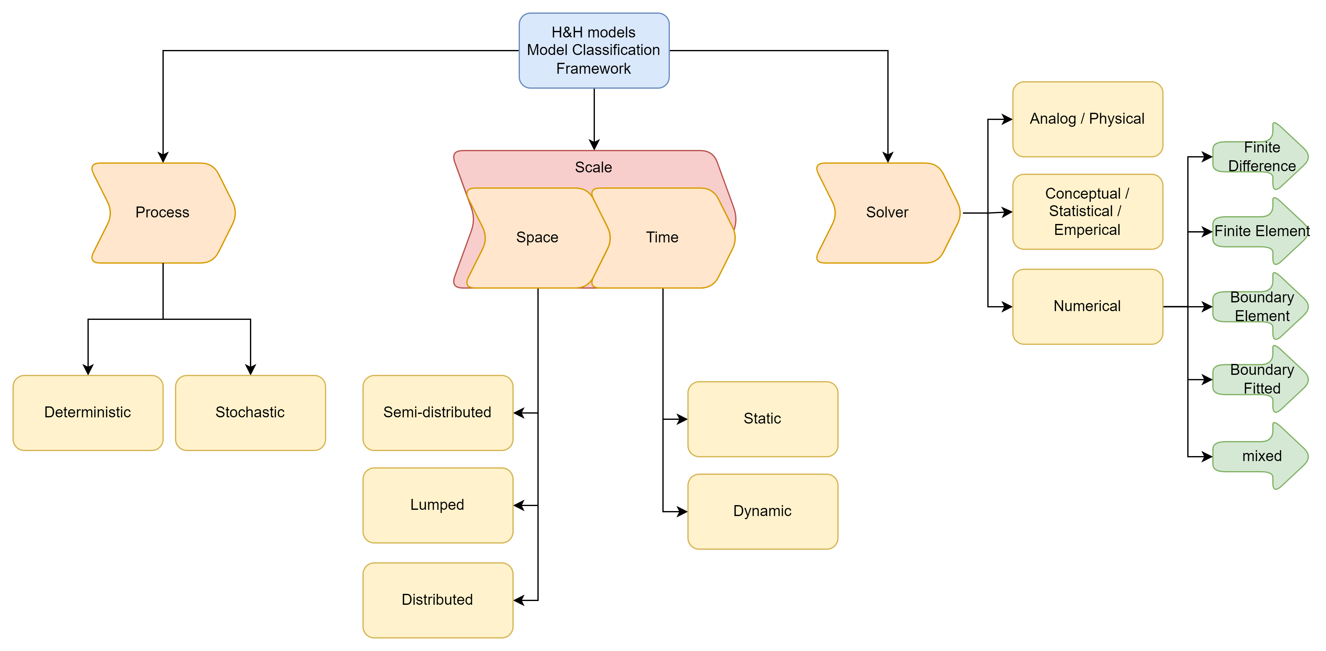
The number of models that represent portions of processes across the hydrologic sciences is almost innumerable. These variations are spurred by technical advances, invested researchers who understand and encode that process in a way that is meaningful to themselves, and innumerable tweaks and forks of those models off which we might want to compare. At their heart though, because these models are all developed by people who have access to the same tools of understanding (in theory at least) and are describing the same system, they have similarities and attributes that call out the meaningful process distinctions and cut through the technical faff that is implementation. Every model, regardless of the process it’s representing or how that representation was implemented, makes a conscious choice as to how it discretizes the scales of space and time, and how it mathematically approaches solving the encoded representation.
Defining “Integrated Hydrologic Modeling Stack”
Related: [[20240509005404]] Defining Integrated Hydrologic Modeling Stack
Earth sciences, and the hydro-centric faction in particular, can be a very fractured community. This is because the scope of the domain is so large you’ll need a few lifetimes before you touch on every interface the hydro-sphere and society share. However, a common angle to approach hydro-problems through is with a so called “H&H” lens. An abbreviation of Hydrologic and Hydraulic sciences, these two domains combine to give us a more meaningful piece of information than the strict applications of the respective fields alone can provide, since Hydrology is really only strictly concerned with mass balance across pools and Hydraulics is really deployed moreso to account for the energy balance of open channel flow. Historically, these two steps used to be performed serially. Most commonly, this is accomplished with some form of HEC-HMS deployed as a way to parameterize the boundary conditions of a HEC-RAS model (substitute your own favorite flavor of model here). Now more commonly referred to as an integrated hydrologic modeling stack, the combination and coupling of these different models has spurred several iterations and promising angles including the 2 way coupling of WRF-Hydro and channel routing modules, the Basic Modeling Interface, and outputs like the National Water Model.
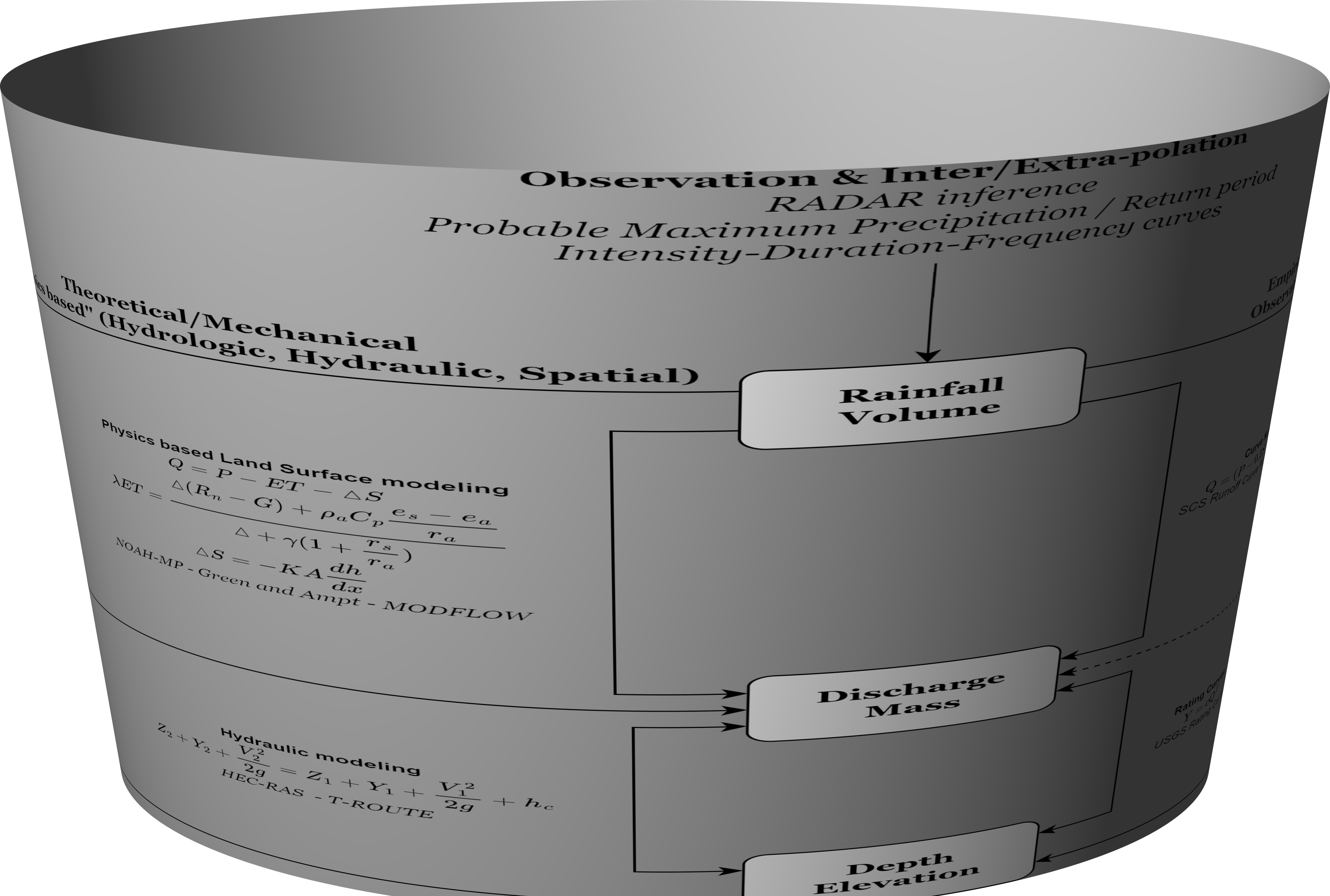
Before we attempt to solve the worlds problems though, it’s worth taking a step back and gaining a lay of the land. With the goal of creating a more accurate flood prediction, we are taking synoptic scale atmospheric weather forcings and predicting an amount of anticipated rainfall. Using that and (occasionally assimilated) land surface model outputs at a 500 meter scale, we predict an amount of in-channel and lateral discharge, which we force into a 250 meter resolution channel routing algorithm. Using 30-10 meter geographic proxies for rating curves, we transform that discharge into a water surface elevation, which we then map to LIDAR scale point clouds (>1 measurement point per meter). That is to say, what we have on our hands is a very messy system of equations and assumptions with which to build a prediction off of, encompassing the cascading uncertainties of each method as we move down the line. This also results in a strange mixing of hats and expertise within and across the different stages of this workflow.
If we were to outline the different approaches, it might look something like so:

A bit pedantic, but I also like to remember that these physics based approaches were all derived off observations, and so it wouldn’t be entirely inappropriate to imagine this in a cylindrical projection.
As if this monumental task wasn’t already complex enough, we need to also account for the fact that the only place along this workflow we have any meaningful control over observations is that last step. While we can get a decent enough prediction of rainfall at a point using measurement techniques like tipping buckets and snow pillows, areal interpolations and extrapolations of rainfall intensities into masses based on RADAR is as close as we get to a meaningful “volume” measurement with any sort of regular spatial coverage. This “measurement” is acronymed as QPF (Quantitative Precipitation Forecast) in recognition that the values reported are cloaked in uncertainty. Likewise, while remote sensing and point soil measurements might get us a a reasonable picture of the amount of water in the uppermost portion of our soil column, we know next to nothing about that distribution at even the hillslope scale, much less the regional unit, and that gross uncertainty extends into groundwater interactions.
Indeed, it’s actually at the river scale where we have any meaningful control over the measurement of the fluxes and also typically the scale where actual solutions are implemented. Weirs may induce a hydraulic jump off which to gather a meaningful and well bounded measurement of fluxes, and USGS river monitoring gages, which involve intensive and repeated velocity / height measurements and proxies are the foundation of many of our model outputs. While stormwater mitigation efforts might be driven from pressures at the watershed/state scale, it’s the swale scale where BMP’s are designed and implemented, and even massive engineering projects like dams are limited in construction footprint to the site along the river.
Unfortunately, it’s also at this stage we hit another wall, this one far more imposing in the form of capital. Measurements of the world are expensive, and high quality or nuanced measurements of the world are even moreso. USGS river gages are typically cited as costing anywhere from $18,000 to $35,000, and a fairly lengthy process of adding new ones. These are also preferentially deployed around urban centers and over bridges, which introduce biases into our observation records.
Extending the stack
This stack gives us an incredibly powerful predictive tool, but it’s important to remember that this is merely a portion of the water cycle, and
Extensions towards impacts
In a very practical and user-oriented viewing, the meaningful answer we are after is likely a far more spatially specific prediction at hyper-resolution scales. Seperations of concern and the desired outcome then dictate how

Extensions from meterology
The meteorological domain provided the foundation (in the form of WRF-Hydro) for much of the stack, but coupled Land-Atmosphere Processes remains on of the more under-explored facets of this stack, and the cascades of uncertainty and scale between that and gage level streamflow have broad ramifications in how certainty, probabilistic, and ensemble predictions are represented.
The National Water Model as an “Integrated Hydrologic Stack”
As alluded to above, H&H is not a “new” approach to water resource forecasting. Indeed, the HEC series of models (HEC-HMS & HEC-RAS) in many regards still represent the gold standard of forecasting, particularly for high flow and design storm approaches. However, one of the key shortcommings in this methodology is that the various components are serial and independent. That limitation, along with the limited scales of analysis most H&H models encompass, was a critical shortfall addressed with the National Water Model.
The National Water Model (NWM) is a hydrologic modeling framework that simulates observed and forecast streamflow over the entire continental United States (CONUS), southern Alaska (Cook Inlet, Copper River Basin, and Prince William Sound regions), Hawaii, Puerto Rico and the US Virgin Islands. Additionally, it produces total water level guidance for the coastlines of those same regions except Alaska. … The NWM produces hydrologic guidance at a very fine spatial and temporal scale. It complements official NWS river forecasts at approximately 4000 locations across the CONUS and produces guidance at millions of other locations that do not have a traditional river forecast. (Office of Water Prediction, n.d.)