Lab 03 - Coordinates and Position Measurements
This lab is a gratefully modified version of lab 2 from Bradley A. Shellito’s Introduction to Geospatial Technologies
In this lab we’ll continue using Google Earth Pro (GEP) to examine coordinate systems and the relationships between various sets of coordinates and the objects they represent in the real world. In addition, we’ll make more measurements using GEP and compare measurements made by using different coordinate systems. The goals for you to take away from this lab:
- Set up a graticule of lines in GEP
- Locate places and objects based only on their coordinates
- Make measurements across long and short distances and then compare measurements with surface distance calculations
- Translate latitude/longitude coordinates into UTM
Outline:
| Data Name | Description |
|---|---|
| GEOG111_Lab3Questions.docx | Handout to turn in |
- Start Google Earth Pro. Once Earth settles into view, scroll your mouse around Earth. You’ll see a set of latitude and longitude coordinates appear at the bottom of the view; these represent the coordinates assigned to your mouse’s location. By default, GEP uses the GCS coordinate system and the WGS84 datum.
- To examine the full graticule of latitude and longitude lines, from the View menu make sure Grid is selected. Some key GCS lines will be highlighted in yellow amid the web of lat/long lines—the Equator, the Prime Meridian, the Antimeridian (how Google Earth labels the 180th meridian), the Tropic of Cancer, and the Tropic of Capricorn.
- We’ll begin our adventure in Lawrence, KS. Type that into the Search box. GEP will rotate and zoom to the area. You’ll also see the spaces between the lat/long lines grow smaller and new values appear as GEP zooms in.
- Next, we’ll go a specific location in Lawrence. Type “38.9584517, -95.251449” into the search box. These are the decimal degree lat/long coordinates of the Lindley Hall.
- Click the Placemark button on the toolbar (Review Lab 1 if you need a quick refresher). The yellow pushpin is automatically placed at the lat/long coordinates you had GEP search for so there’s no need to manually place it. In the new placemark dialog box, type “Lindley Hall” and change the pin symbology to something you like.
- The coordinates for Lindley Hall are in decimal degrees, but other methods of displaying coordinates are available in GEP. From the Tools pull-down menu, select Options. In the Show Lat/Long options, select the radio button next to Degrees, Minutes, Seconds, click Apply and then OK.
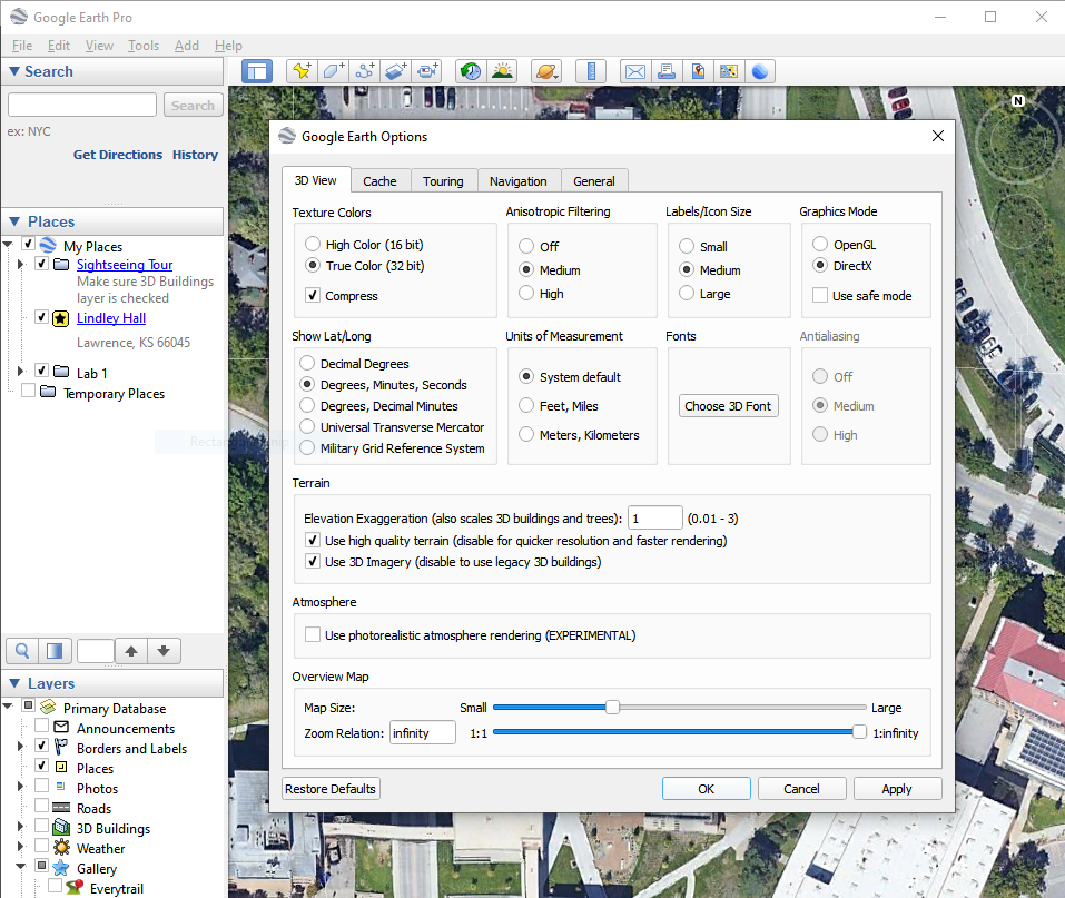
From the Places box in GEP, right-click on the placemark Lindley Hall and then select Properties. The coordinates are changed to degrees, minutes, and seconds (DMS). Answer Question 1. Close the Lindley Hall placemark dialog box.
Question 1
What are the coordinates for Lindley Hall, in degrees, minutes, and seconds?
- Decimal degree coordinates for Thai Diner are “38.9435517, -95.2424942”. Use the Search box to zoom to these coordinates and put a placemark at that spot. Name it Thai Diner, and answer Question 2.
Question 2
What are the coordinates for the Thai Diner, in degrees, minutes, and seconds?
- Adjust the view so you can see both placemarks at the edges of the view. Select the Ruler tool and compute the distance between the Lindley Hall and the Thai Diner (again, review Lab 1 if you need a quick refresher). Answer Question 3.
Question 3
According to GEP, what is the distance between Lindley Hall and Thai Diner?
It’s such a short distance (relative to the size of the globe) from Lindley Hall to Thai Diner that the differences between measurements should be very small, so let’s look at some larger distances.
- Lindley Hall (in London, England) is located at “51.4944692, -0.1344998”. Use the Search box to zoom to these coordinates. Once GEP arrives there, put a placemark at that spot, name it “Lindley Hall, London”, and then answer Question 4
Question 4
What are the coordinates for Lindley Hall, London, in degrees, minutes, and seconds?
- Use the Ruler to compute the distance between Lindley Hall and Lindley Hall, London. You will have to pan and zoom to get the ruler to measure between both locations. Answer Questions 5 and 6. Close the Ruler dialog box when you’re done.
Question 5
According to your measurement in GEP, what is the computed distance (in miles) between the Lindley Hall and Lindley Hall, London?
Question 6
Why is the line curved rather than straight? What kind of distance is being computed here?
Of course, this is a rough estimate because the scale of the view and the imprecise nature of your point and click makes hitting the placemarks directly with the start point and the end point of the ruler difficult.
- To check your measurements using a Web utility, go to https://www.movable-type.co.uk/scripts/latlong.html. This Website enables you to compute the surface (real-world) distance between two sets of lat/long coordinates. Type your answer to Question 1 as the degrees, minutes, and seconds for the latitude and longitude of Point 1, and your answer from Question 4 in Point 2.
Note that you can simply write each of those coordinates with a space in between them; for instance, 40 degrees, 41 minutes, 52 seconds North latitude can be typed in the box as 40 41 52 N.
- Click the see it on a map button. The surface distance between the two points is computed in kilometers, and a zoomable map of the great circle distance from Lindley Hall to Lindley Hall, London is displayed for you.
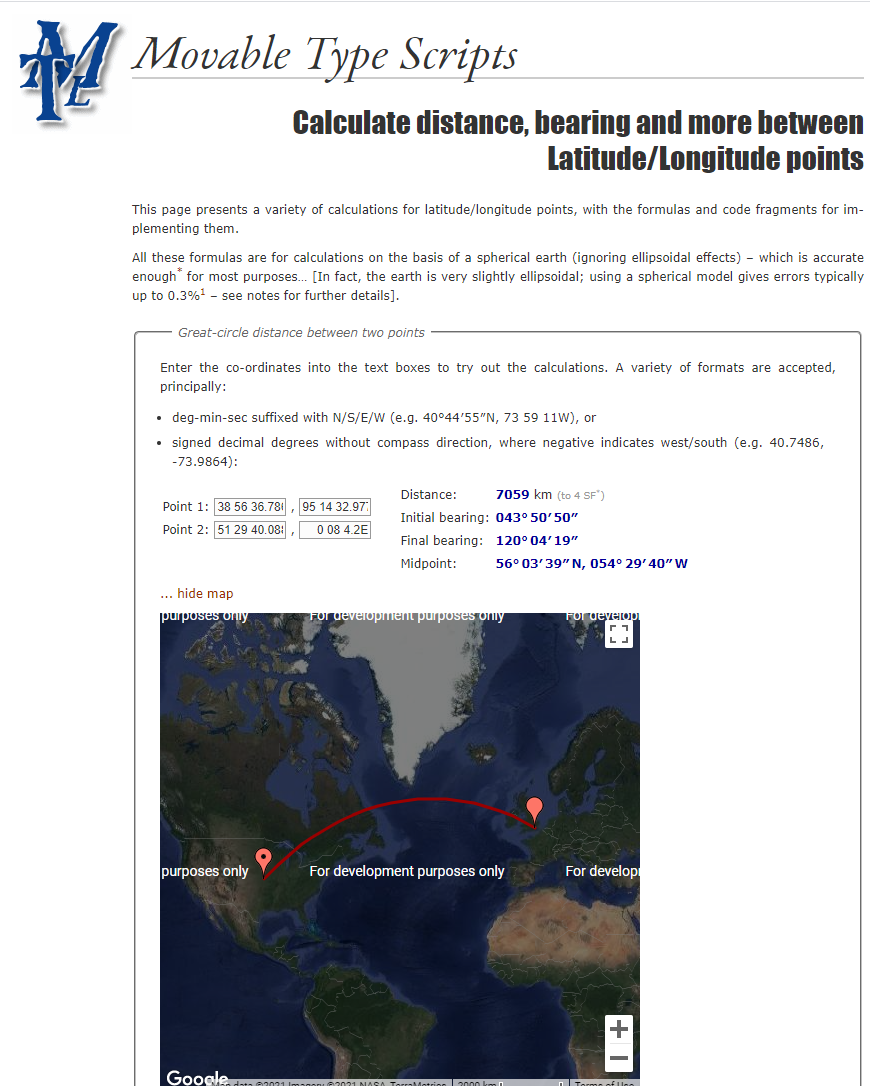
- Finally, convert you answer from km to miles (a simple Google search will accomplish this, “### km to miles”). Answer Question 7.
Question 7
According to this website measurement, what is the computed surface distance (in miles) between the Lindley Hall and Lindley Hall, London?
Your answers to Questions 5 and 7 should be relatively similar, given how they were both computed; if they’re way off, redo your Question 5 measurement and make sure you’re inputting the correct numbers for Question 7.
- Universal Transverse Mercator (UTM) is a projected coordinate system, and GEP can track coordinates using this UTM system as well as lat/long. From Tools on the menu bar, select Options. In the Show Lat/Long options, select the radio button for Universal Transverse Mercator, click Apply and then OK.
UTM coordinates are measured in meters rather than degrees of latitude or longitude, which enables an easier method of determining coordinates. Moving the mouse east increases your easting, and moving it west decreases the easting. The same holds true for northing: Moving the mouse north increases the value of northing, and moving it south decreases the northing value.
- Zoom out to see the whole world. You’ll also see that the graticule has changed from a web of latitude/longitude lines to the UTM grid draped over Earth. You should see the UTM zones laid out across the world, numbered from 1 through 60. Answer Question 8.
Question 8
In what UTM zone is Lindley Hall, London located? In what UTM zone is Lindley Hall located?
- Double-click on the Lindley Hall placemark(in the Places box), and GEP rotates and zooms back to the Lindley Hall. Scroll the mouse around the area. You’ll see new coordinates appear at the bottom of the view, but this time they are the zone, easting, and northing measurements. Open the Properties of The Lindley Hall placemark by right-clicking on it. The UTM easting, northing, and zone appear. Using these methods, answer questions 9 and 10.
Question 9
What are the UTM coordinates of the Lindley Hall?
Question 10
What are the UTM coordinates of the Thai Diner?
- Change the view so that you can see both Lindley Hall and Thai Diner. Using your answers for Questions 9 and 10 (and perhaps the Ruler tool or some basic arithmetic/trigonometry), answer Question 11.
Question 11
How many meters away to the north and east is Lindley Hall from Thai Diner?
- UTM can also be used to easily determine the locations of other objects. Return to the Lindley Hall placemark again. Answer Questions 12 and 13.
Question 12
What object is located approximately 66.69 meters north and 692 meters east of Lindley Hall?
Question 13
What are the full UTM coordinates of this object?
There is no need to save anything from this lab, so when done you can simply close without saving. Submit your answers to the questions on blackboard.